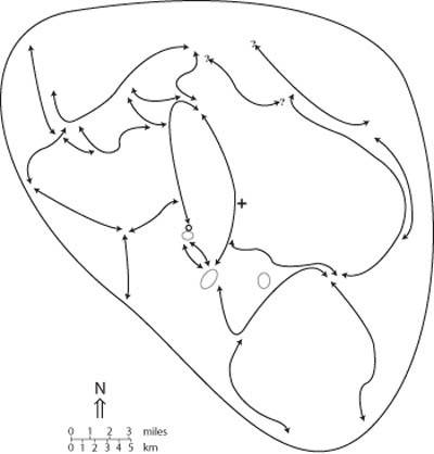
Below is another example of the Fishtrap pack's approximate territorial limits and the travel routes they used. They tended to use the extensive logging road system when traveling, rather than always bushwhacking through the forest. The larger blank areas were locations of mountain peaks. The small black circle was the den site location, and the gray ovals were known and repeatedly used rendezvous sites. These areas were where the pack took the pups at the end of the denning season, and rotated through during the summer months. By fall, the pack became nomadic until the following spring when denning season began. The question marks were for roads where I only occasional found a wolf print or scat and didn't know if the wolves used the entire length of the road or not.